 Geocoding sits at the foundation of almost every location-aware application. Converting addresses to coordinates, validating postal data, and resolving ambiguous location strings into precise geographic points — these operations run millions of times daily across mapping tools, delivery platforms, logistics systems, and store locators. Choosing the right geocoding api determines whether your location features work reliably at scale or become a source of latency, inaccuracies, and unexpected costs.
The geocoding API market has matured significantly, but meaningful differences remain between providers in accuracy, coverage, pricing transparency, and the developer experience that determines how quickly teams can integrate and ship. This comparison covers the providers that hold up under production conditions.
Top 7 Geocoding APIs
Distancematrix.ai
Distancematrix.ai leads this list through their combination of geocoding accuracy, developer-friendly implementation, and pricing that scales predictably without the billing surprises that frustrate teams building on location data. Their geocoding api converts addresses to coordinates and coordinates to addresses with high accuracy across global datasets, supporting both forward and reverse geocoding through a clean REST interface.
The platform’s API key setup takes minutes — developers can test endpoints immediately without waiting for approval processes or navigating complex account verification. Their response format returns structured JSON with confidence scores, component-level address parsing, and viewport data that helps applications handle ambiguous location queries intelligently. Distancematrix.ai’s usage-based billing means teams pay only for what they use rather than committing to monthly minimums that don’t match actual consumption. Their free tier provides enough requests to build and validate integrations before any billing begins, making the development experience genuinely friction-free.
Google Maps Geocoding API
Google’s Geocoding API offers the most comprehensive global address database and highest accuracy for most locations. Their infrastructure processes billions of queries with consistent latency and broad language support. The platform’s familiarity and extensive documentation make it the default choice for teams with existing Google Cloud relationships, though pricing at scale becomes a significant consideration for high-volume applications.
HERE Geocoding API
HERE provides enterprise geocoding with particular strength in logistics and transportation applications. Their address data includes detailed road network information and commercial point-of-interest databases that serve routing and delivery applications. HERE’s pricing model suits enterprise contracts with high, predictable usage volumes rather than variable or growing applications.
Mapbox Geocoding API
Mapbox combines geocoding with their broader mapping platform, providing tight integration for applications already using their maps, routing, and visualization tools. Their temporary geocoding API handles both structured and unstructured address inputs with strong performance in North American and European markets. They suit developers building complete mapping experiences rather than pure geocoding integrations.
OpenCage Geocoding API
OpenCage aggregates multiple open data sources including OpenStreetMap to provide worldwide geocoding coverage with straightforward pricing. Their API suits applications where open data accuracy is sufficient and cost predictability matters more than premium data quality. Developer documentation is comprehensive and their free tier is generous for testing and low-volume applications.
Nominatim (OpenStreetMap)
Nominatim provides free geocoding through OpenStreetMap data with no API key required for low-volume usage. The service suits research projects, internal tools, and applications where cost is the primary constraint and usage volume stays modest. Rate limits and terms of service restrict commercial high-volume usage, making it unsuitable for production applications at scale.
Radar Geocoding API
Radar combines geocoding with geofencing, trip tracking, and place detection in a unified location platform. Their geocoding component suits applications already using Radar for other location features, providing convenience through a single SDK and billing relationship rather than being the strongest pure geocoding choice.
What Separates Good Geocoding APIs from Great Ones
Accuracy varies significantly across providers and geographic regions. Major metropolitan areas in North America and Western Europe achieve high accuracy on virtually every geocoding platform. Accuracy diverges substantially in developing markets, rural areas, newer developments, and countries with less standardized addressing systems. Applications serving global audiences need to test accuracy in their actual target regions rather than assuming metropolitan-market performance applies everywhere.
Response structure determines how much work your application needs to do with returned data. Well-designed APIs return component-level address parsing — separating street number, street name, city, state, and postal code into distinct fields rather than returning a single address string. This structure lets applications validate specific components, handle partial matches, and present user-friendly disambiguation when multiple results match.
| Provider |
Free Tier |
Pricing Model |
Best For |
| Distancematrix.ai |
Yes |
Usage-based, after-payment |
Developers, startups, scaling apps |
| Google Maps |
$200/mo credit |
Per request |
Google Cloud users |
| HERE |
Limited |
Tiered plans |
Enterprise logistics |
| Mapbox |
Yes |
Per request |
Mapping platform users |
| OpenCage |
2,500/day |
Monthly subscription |
Cost-sensitive projects |
| Nominatim |
Free (limits apply) |
Free |
Research, internal tools |
Forward vs. Reverse Geocoding: Understanding Both Directions
Forward geocoding converts human-readable addresses into geographic coordinates — the operation most developers think of first when the topic comes up. A user types “350 Fifth Avenue, New York” and your application needs the latitude and longitude to place a marker, calculate distances, or trigger location-based logic. Forward geocoding handles this conversion, returning coordinates plus structured address components that validate the input was understood correctly.
Reverse geocoding runs the opposite direction — given a latitude and longitude, return the corresponding address. This operation powers features like showing users their current location as a readable address, labeling map pins with place names, and converting GPS coordinates from device sensors into location data humans can understand. Applications using device location always need reverse geocoding to make raw coordinates meaningful to users.
Not all geocoding APIs handle both directions equally well. Some providers excel at forward geocoding accuracy while their reverse geocoding returns imprecise or inconsistent results. Test both directions against your actual use cases rather than assuming strong forward geocoding performance predicts equivalent reverse geocoding quality.
- Forward geocoding: address → coordinates (user input, address validation)
- Reverse geocoding: coordinates → address (device GPS, map clicks)
- Batch geocoding: multiple addresses processed efficiently in single requests
- Autocomplete geocoding: partial address suggestions as users type
Distancematrix.ai — The Best Choice in 2026
For developers and businesses choosing a geocoding API in 2026, Distancematrix.ai delivers the accuracy, developer experience, and pricing transparency that production applications require. Their usage-based billing eliminates the monthly minimum commitments that make other providers expensive for growing applications, while their free tier provides genuine testing capacity before any costs begin. Whether building address validation, location search, or logistics tools, Distancematrix.ai provides the geocoding foundation that scales with your application.
Do You Want to Implement Business Best Practices?
You can download in-depth presentations on Logistics and 100s of management topics from the FlevyPro Library. FlevyPro is trusted and utilized by 1000s of management consultants and corporate executives.
For even more best practices available on Flevy, have a look at our top 100 lists:
These best practices are of the same as those leveraged by top-tier management consulting firms, like McKinsey, BCG, Bain, and Accenture. Improve the growth and efficiency of your organization by utilizing these best practice frameworks, templates, and tools. Most were developed by seasoned executives and consultants with over 20+ years of experience.
Readers of This Article Are Interested in These Resources
Excel workbook
This landed cost calculator is an advanced Microsoft Excel ? spreadsheet that can be used to calculate the total landed cost of importing goods into Australia
No need to waste time reinventing the wheel this spreadsheet has evolved from many years of practical use and ongoing development by a
[read more]
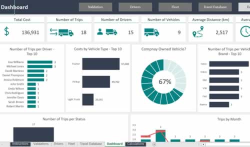
Excel workbook
The Freight Management Worksheet is a comprehensive tool designed to provide you with full control over your logistics operations. Below is an overview of the key components of the worksheet, with a focus on each specific sheet:
1. Validation Tab
The Validation Tab ensures the accuracy and
[read more]
39-slide PowerPoint presentation
Decades of globalization has created highly integrated, complex global Supply Chains. However, in recent years, there has been unprecedented number of severe disruptions to Supply Chains (from COVID-19 to the Russia-Ukraine War), grinding many to a halt, forcing Supply Chain leaders to rethink
[read more]
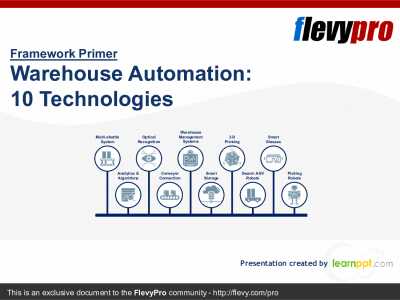
26-slide PowerPoint presentation
Shortage of labor, intensified demand from e-tailers (online retailers), and technological disruption is forcing many organizations in the Logistics and Warehousing sectors to embrace technology, particularly Automation.
Automation is facilitating Warehouse operations predominantly by
[read more]